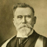
Robert Bell
#91,847
Most Influential Person Across History
Canadian geologist
Robert Bell 's AcademicInfluence.com Rankings
Download Badge
Earth Sciences
Robert Bell 's Degrees
- Masters Geology University of British Columbia
- PhD Geology University of Calgary
Why Is Robert Bell Influential?
(Suggest an Edit or Addition)According to Wikipedia, Robert Bell was a Canadian geologist, professor and civil servant. He is considered one of Canada’s greatest exploring scientists, having named over 3,000 geographical features. Personal life Robert Bell was born in Toronto, Upper Canada to Presbyterian clergy and amateur geologist, Reverend Andrew Bell and Elizabeth Notman. In 1873, Bell married Agnes Smith. They had a son and three daughters. He spent his retirement at his home in Ottawa and his farm in Rathwell, Manitoba. Bell died after a brief illness at the age of 76 at his farm.
Robert Bell 's Published Works
Number of citations in a given year to any of this author's works
Total number of citations to an author for the works they published in a given year. This highlights publication of the most important work(s) by the author
Published Works
- Geological Survey of Canada (1885) (809)
- Report of the Special Committee for the Lake Superior Region (1905) (11)
- Proofs of the rising of the land around Hudson Bay (1896) (10)
- On the English Crags and the Stratigraphical Divisions indicated by their invertebrate fauna (1872) (6)
- On the Pliocene Beds of St. Erth (1886) (6)
- Report on the country between Lake Superior and Lake Winnipeg (5)
- On Glacial Phenomena in Canada (5)
- Report on explorations of the Churchill and Nelson Rivers and around God's and Island Lakes, 1879 / (4)
- On the natural history of the Gulf of St. Lawrence and the distribution of the Mollusca of Eastern Canada (4)
- Report on the country between Lake Superior and the Albany River (3)
- Map of part of the East Coast of Hudsons Bay (3)
- Report on the geology of the French River sheet, Ontario (3)
- Report on Hudson's Bay and some of the lakes and rivers lying to the west of it (3)
- Map of Part of the Athabasca River (3)
- Report on the Sudbury mining district, to accompany sheet 130, series of geologically coloured maps of Ontario (2)
- Evidences of northeasterly differential rising of the land along Bell River (2)
- Reports on the geology of the basin of Moose River and of the Lake of the Woods and adjacent country, 1881 by Robert Bell. (2)
- Report on part of the Athabasca River, Northwest Territory (2)
- Report of an exploration on the northern side of Hudson Strait (2)
- Report on the geology of the northwest side of Lake Superior, and of the Nipigon district (2)
- THE HUDSON BAY ROUTE TO EUROPE. (1910) (1)
- IV.—The English Crags, and their Stratigraphical Divisions indicated by their Invertebrate Fauna (1871) (1)
- VI.—Notes on Pliocene Beds (1887) (1)
- Observations on the geology, zoology and botany of Hudson's Strait and Bay made in 1885 by Robert Bell. (1)
- Report on the country north of Lake Superior, between the Nipigon and Michipicoten rivers (1)
- Summary report of the Geological Survey department, for the calendar year 1903 (1)
- Summary report of the operations of the Geological Survey for the year 1904 (1)
- III.—Land Shells in the Red Crag (1884) (1)
- Summary report of the Geological Survey of Canada for the calendar year 1905 (1)
- The forests of Canada by Robert Bell. (0)
- Summary report of the Geological Survey department, for the year 1901 (0)
- Sawdust Explosion (1889) (0)
- Summary report of the operations of the Geological Survey for the calendar year 1903 (0)
- Manitoulin Island Sheet, Algoma District, Province of Ontario (0)
- Rock Specimens from Cumberland Sound, Baffin Land (1887) (0)
- Geological Survey of Canada, reports and maps of investigations and surveys [for the year 1900] (0)
- Appendix V: Catalogue of animals and plants collected and observed, on the south-east side of the St. Lawrence from Quebec to Gaspé, and in the counties of Rimouski, Gaspé and Bonaventure (0)
- Appendix: on the plants of the Manitoulin Islands (0)
- Map of Nelson River and the boat-route between Lake Winnipeg and Hudson's Bay (0)
- Map Showing Approximately the Geology of the Basin of Moose River and Adjacent County, Ontario (0)
- Geological map of the Lake of the Woods and Adjacent Country, Ontario (0)
- Report of Mr. Robert Bell addressed to Sir William E. Logan [on the Manitoulin Islands] (0)
- Map of Lake Winnipeg, Manitoba (0)
- Observations on the geology, zoology and botany of the Labrador coast, Hudson's Strait and Bay (0)
- Legends of the Slavey Indians of the Mackenzie River (0)
- Summary report of the operations of the Geological Survey for the year 1901 (0)
- Province of Ontario, Nipissing, Algoma and Parry Sound districts, French River sheet (0)
- Rock Specimens from Cumberland Sound. Baffin Land. (1887) (0)
- Report on the country west of lakes Manitoba and Winnipegosis, with notes on the geology of Lake Winnipeg (0)
- Map of the coasts of Hudson Strait and Ungava Bay, districts of Franklin and Ungava (0)
- Sudbury sheet, No 130, districts of Algoma and Nipissing, Province of Ontario (0)
- Summary report of the operations of the Geological Survey for the calendar year 1902 (0)
- On the occurrence of Mammoth and Mastodon remains around Hudson Bay by Robert Bell. (0)
- Map shewing the general northern limits of the principal forest trees of the Dominion of Canada (0)
- The geographical distribution of the forest trees of Canada by Robert Bell. (0)
This paper list is powered by the following services:
Other Resources About Robert Bell
What Schools Are Affiliated With Robert Bell ?
Robert Bell is affiliated with the following schools:
